
Why sheep need open data
On Monday 19 May in collaboration with the ODI, Horizon is hosting a workshop, grandly entitled:
 About 10 years ago I bought the field next to my house; two border collies need space to stretch their legs....
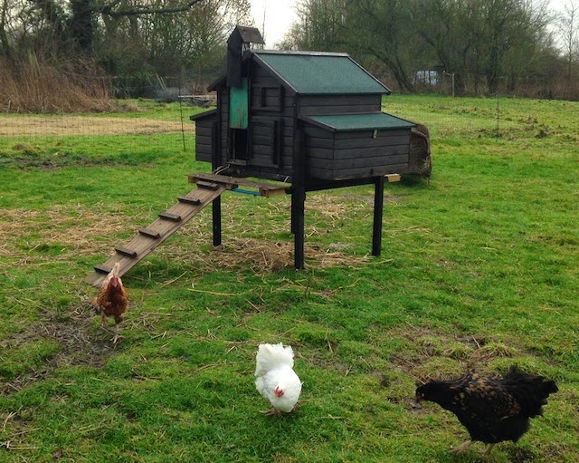
Then we thought chickens. DEFRA regulations require that if you keep 50 or more birds then you need to register - we've not taken to supplying the village with eggs, so we were able to avoid this piece of agricultural bureaucracy.
Until we very recently decided sheep. One sheep and you need to register. You need a "County Parish Holding" number which you obtain by phoning the nice folks at Rural Payments Agency and providing "postcode or OS Grid Reference(s)" - postcode not much use as it covers most of the village, but my O-level geography seemed to mostly consist of providing and looking up OS Grid References so I can do that.
Then I thought - when I bought this land it was lodged with the Land Registry; would it not be great if I could simply refer to the registry entry and then DEFRA would know not only some point in the middle of a field, but know the boundaries. That might be joined up.
However, I was saddened to remember that I had previously been looking for a digital representation of the boundaries for my home on a planning permission matter [1] and it was not readily available - seemed historically such dangerous digital information was reserved for "the trade".
I'm not a geospatial expert so was only aware in principle of the EU INSPIRE activity, but not the detail. So I was pleased to hear this week at a Big Data event at RAL from the Land Registry that, prompted by INSPIRE, and as part of their open data initiative, the "index polygon" data for land registered with them [2] is now available under OGL. It can be visualized on data.gov.uk directly, or downloaded in chunks from the Land Registry site (warning many files!). It is in GML format, so I had to dust off the Quantum GIS [3], but now have the open data happiness of being able to work with the authoritative data.
Still can't send it to DEFRA though; and likewise, now that I have my CPH number from DEFRA I'm not actually sure what they have on record as the land concerned, so still plenty of room for improvement and joined up thinking.
Which leads us to the topic of the workshop - how many other sources of information (public and private) out there could we be pulling together around the environment in which we live and what new services could we offer. My semi agricultural example is simple compared to the complexity of, say, providing a service that allows Joe Public to send an alert to the tenant in a multi occupancy building that water is gushing out of their flat even though Joe should never know who the tenant is (N.B. posts passim on privacy).
Join us - the wilder the speculation the better the result :-)
[1] You can deface your property and the neighborhood with solar panels on the roof but woe betide you if you want to install them at the bottom of your garden out of sight behind a 6ft fence - you'll need planning for that!
[2] Currently for freehold registries.
[3] Quantum GIS is a free and open source Geograpical Information System.
Show me the future of: the built environment and open dataSo what's it all about? I've been on a journey...
About 10 years ago I bought the field next to my house; two border collies need space to stretch their legs....
Then we thought chickens. DEFRA regulations require that if you keep 50 or more birds then you need to register - we've not taken to supplying the village with eggs, so we were able to avoid this piece of agricultural bureaucracy.
Until we very recently decided sheep. One sheep and you need to register. You need a "County Parish Holding" number which you obtain by phoning the nice folks at Rural Payments Agency and providing "postcode or OS Grid Reference(s)" - postcode not much use as it covers most of the village, but my O-level geography seemed to mostly consist of providing and looking up OS Grid References so I can do that.
Then I thought - when I bought this land it was lodged with the Land Registry; would it not be great if I could simply refer to the registry entry and then DEFRA would know not only some point in the middle of a field, but know the boundaries. That might be joined up.
However, I was saddened to remember that I had previously been looking for a digital representation of the boundaries for my home on a planning permission matter [1] and it was not readily available - seemed historically such dangerous digital information was reserved for "the trade".
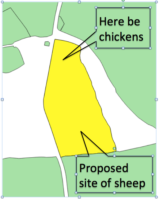 |
| This information is subject to Crown copyright and |
| is reproduced with the permission of Land Registry |
Still can't send it to DEFRA though; and likewise, now that I have my CPH number from DEFRA I'm not actually sure what they have on record as the land concerned, so still plenty of room for improvement and joined up thinking.
Which leads us to the topic of the workshop - how many other sources of information (public and private) out there could we be pulling together around the environment in which we live and what new services could we offer. My semi agricultural example is simple compared to the complexity of, say, providing a service that allows Joe Public to send an alert to the tenant in a multi occupancy building that water is gushing out of their flat even though Joe should never know who the tenant is (N.B. posts passim on privacy).
Join us - the wilder the speculation the better the result :-)
[1] You can deface your property and the neighborhood with solar panels on the roof but woe betide you if you want to install them at the bottom of your garden out of sight behind a 6ft fence - you'll need planning for that!
[2] Currently for freehold registries.
[3] Quantum GIS is a free and open source Geograpical Information System.
Written on May 10, 2014